|
|
|
|
|
| A41 | Mid Western Highway & Olympic Highway (A41) |
Statistics:
Route Numbering:


General Information:
A41 is a rural highway in western and southern New South Wales. It services rural communities and links the Hume Highway with the Mitchell & Great Western Highways (A32) and Sturt Highway (A20).
The Bathurst to Cowra section of the route, the Mid Western Highway, forms part of the most direct route between Sydney or Brisbane and Adelaide (via Hay), and consists of mainly two-lane rural highway standard.
The Cowra to Table Top section of the route was named Olympic Way, as it was the path that the Olympic Torch took on its journey to Melbourne for the 1956 Summer Olympics. The torch was carried from Cairns to Melbourne. For the 1956 Summer Olympics the Olympic Flame, or torch, was carried along the road from Cowra to Wagga Wagga. For the 2000 Summer Olympics the torch was carried from Wagga Wagga to Cowra en route to Sydney. 2
The Olympic Highway section featured the Kapooka Bridge which crossed the railway line at Kapooka. It was built in 1880 and features 2 right angle bends at the approaches to the bridge, which have been the scene of several crashes. 3
Multiplexes along the route include:
History:

| Table Top to Bathurst | Bathurst to Table Top | |||
| Preview: | Description: | Preview: | Description: | |
 |
Distance
Sign: RD sign on Olympic Hwy (A41) at Table Top, May 2011. Image © Rob Tilley |
 |
Advance
Directional Sign: AD sign on Mitchell Hwy (A32) approaching Great Western Hwy (A32), Mid Western Hwy (A41) and Brilliant St in Bathurst, August 2013. Image © Peter Renshaw |
|
 |
Distance
Sign: RD sign in Wagga Wagga, May 2011. Image © Rob Tilley |
 |
Intersection
Directional Sign: ID sign at the roundabout with Mitchell Hwy (A32), Great Western Hwy (A32) and Brilliant St in Bathurst, August 2013. Image © Peter Renshaw |
|
 |
Reassurance
Directional Sign: Distance sign at Boorooma, May 2011. Image © Rob Tilley |
 |
Reassurance
Directional Sign: Distance sign on Mid Western Hwy (A41) at Bathurst, August 2013. Image © Peter Renshaw |
|
 |
Advance Directional Sign : AD sign approaching Mid Western Hwy (B64) and Mid Western Hwy (A41) at Cowra, September 2013. Image © Paul Rands |
 |
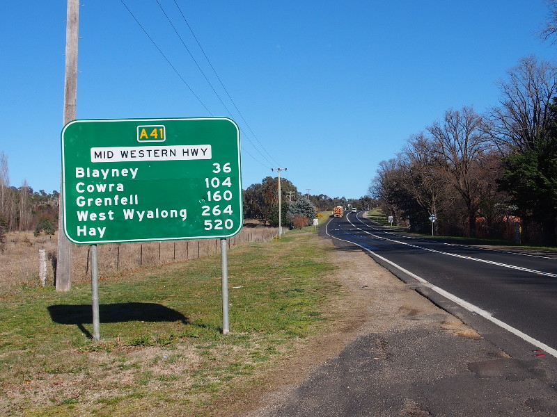
AD
Sign: AD sign on Hobby's Yards Road approaching Mid Western Highway (A41) at Blayney, August 2013. Image © Peter Renshaw |
|
 |
Advance Directional Sign: AD sign in Cowra approaching Lachlan St (B81 and unnumbered), September 2013. Image © Paul Rands |
 |
ID
Sign: Intersection directional sign facing Carcoar Dam Rd at Blayney, December 2012. Image © Paul Rands |
|
 |
Advance Directional Sign : AD sign approaching Fitzroy St, Cowra, September 2013. Image © Paul Rands |
 |
Intersection
Directional Sign: ID sign assembly facing Nargong Rd at Woodstock, August 2013. Image © Peter Renshaw |
|
 |
Reassurance Directional Sign : Distance sign at Mid Western Hwy (A41) leaves Cowra, September 2013. Image © Paul Rands |
 |
ID
Sign: Intersection directional sign facing Walli Rd, Woodstock, December 2012. Image © Paul Rands |
|
 |
Advance Directional Sign : AD sign at Woodstock approaching George Russell Dr and Reg Hailstone Way, September 2013. Image © Paul Rands |
 |
Intersection
Direction Signs: ID signs facing Lachlan Valley Way (B81) at Cowra, December 2012. Image © Paul Rands |
|
 |
Distance
Sign: RD sign as Mid Western Hwy (A41) leaves Woodstock, August 2013. Image © Peter Renshaw |
 |
Advance
Directional Sign: AD sign approaching Ashmont St and the Olympic Hwy (A41) and Sturt Hwy (A20) split at Moorong, May 2011. Image © Rob Tilley |
|
 |
Advance Directional Sign : AD sign approaching Belubula Way, Mandurama, September 2013. Image © Paul Rands |
 |
Distance
Sign: RD sign on Olympic Hwy (A41) at Moorong, May 2011. Image © Rob Tilley |
|
 |
Entering Blayney : Mid Western Hwy (A41) entering the town of Blayney, September 2013. Image © Paul Rands |
 |
Advance
Directional Sign: AD sign approaching Camp Access Rd at Kapooka, May 2011. Image © Rob Tilley |
|
 |
Advance Directional Sign : AD sign approaching Hobby's Yards Road in Blayney, September 2013. Image © Paul Rands |
 |
Advance
Directional Sign: AD sign approaching Camp Access Rd at Kapooka, May 2011. Image © Rob Tilley |
|
 |
Advance Directional Sign : AD sign near Adelaide St North and Maria St in Blayney, September 2013. Image © Paul Rands |
 |
Advance
Directional Sign: AD sign at Table Top approaching Hume Hwy (M31), May 2011. Image © Rob Tilley |
|
 |
Distance Sign : RD sign leaving Blayney, September 2013. Image © Paul Rands |
 |
Advance
Directional Sign: AD sign at Table Top approaching Hume Hwy (M31), May 2011. Image © Rob Tilley |
|
 |
Fitzgeralds Mount: Mid Western Hwy (A41) as it makes its way down Fitzgeralds Mount, September 2013. Image © Paul Rands |
 |
Hume
Highway: Intersection directional sign at the junction with Hume Hwy (M31) at Table Top, May 2011. This is the southern terminus of A41. Image © Rob Tilley |
|
 |
Steep Descent Sign : Warning sign for steep descent down Fitzgeralds Mount, September 2013. Image © Paul Rands |
|||
 |
Fitzgeralds Mount: Mid Western Hwy (A41) as it makes its way down Fitzgeralds Mount, September 2013. Image © Paul Rands |
|||
 |
Special Truck & Bus Speed Limit: Special truck & bus speed limit as Mid Western Hwy (A41) as it makes its way down Fitzgeralds Mount, September 2013. Image © Paul Rands |
|||
 |
Fitzgeralds Mount: Mid Western Hwy (A41) as it makes its way down Fitzgeralds Mount, September 2013. Image © Paul Rands |
|||
 |
Advance Directional Sign : AD sign approaching the roundabout with Brilliant St, Mitchell Hwy (A32) and Great Western Hwy (A32) in Bathurst, September 2013. Image © Paul Rands |
|||
 |
End A41 : Northern terminus of A41: the roundabout with Brilliant St, Mitchell Hwy (A32) and Great Western Hwy (A32) in Bathurst, September 2013. Image © Paul Rands |
|||
 |
Intersection Directional Sign : ID sign on the roundabout with Brilliant St, Mitchell Hwy (A32) and Great Western Hwy (A32) in Bathurst, September 2013. Image © Paul Rands |
|||
1 Roads &
Traffic Authority, Schedule of Classified Roads and State & Regional
Roads, 31 January 2011
2 Olympic Highway, Lambert M. Surhone ,
Mariam T. Tennoe , Susan F. Henssonow ISBN: 9786135069341
3 Roads & Traffic Authority,
Community Update, Realignment
of the Olympic Highway at Kapooka, December 2010.
4 Journal of Department of Main Roads
New South Wales, Extract from September 1958 issue of "Main Roads"
5 The Sydney Morning Herald, Apr
5, 1973
6 Historic Properties For Sale or
Lease, Bridge Tearooms
7 Roads & Traffic Authority,
Construction and Maintenance, Regional Projects, Western,
Pavementreconstruction at Goldsby Hill
8 Parliament of New South Wales,
Hansard & Papers, Legislative Council, Bathurst
Electorate
Roadworks No. 58, 19 October 1995
9 Roads & Traffic Authority, Road
Activity
Update - Western NSW, February 2003
10 Roads & Traffic Authority, Road
Activity Update - Western NSW, June 2003
Last updated: 2-jan-19 19:27
This site © Paul Rands. All rights reserved. Some portions © (copyright) by their respective and credited owners. Permission must be obtained before using any images from this site. For details, please email by clicking here.