|
|
|
|
|
| Port Curtis Way, Hanson Road, Glenlyon Road & Philip Street (State Route 58) |
Statistics:
Route Numbering:
General Information:
State Route 58 is a arterial route in the Gladstone area. The route connects the city with the Bruce Highway, and passes through industrial, commercial and residential zones, it also goes through several bushland zones as well.
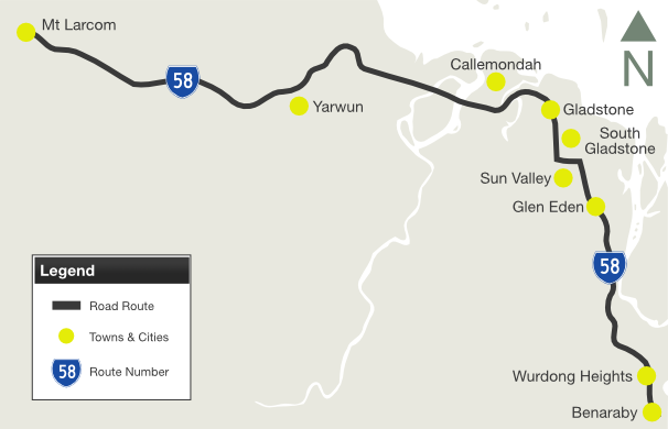
| Mt Larcom to Benaraby | Benaraby to Mt Larcom | |||
| Preview: | Description: | Preview: | Description: | |
 |
Advance
Directional Sign: AD sign at Yarwun approaching the entrance to Rio Tinto, January 2014. Image © Terry Siva |
|
 |
Distance Sign: RD sign on Port Curtis Way (SR58) at Wurdong Heights, June 2010. Image © Rob Tilley |
 |
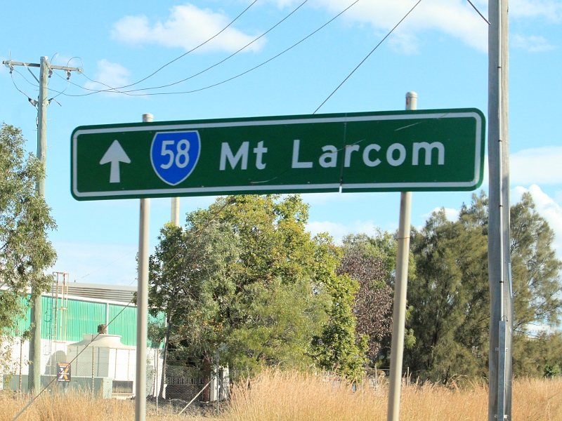
Advance
Directional Sign: AD sign on Alforourke Dr approaching Blain Dr, Hanson Rd (SR58) and Port Curtis Way (SR58) at Callemondah, June 2010. Image © Rob Tilley |
 |
Advance Directional Sign: AD sign approaching Boyne Island Rd at Wurdong Heights, June 2010. Image © Rob Tilley |
|
 |
Gladstone
port
Access Road & Railway Street: Glenlyon Rd (SR58) at Gladstone Port Access Rd and Railway St in Gladsone, June 2010. Image © Rob Tilley |
 |
Supplemental
Advance Directional Sign: Supplemental AD sign approaching Boyne Island Rd at Wurdong Heights, June 2010. Image © Rob Tilley |
|
 |
Intersection
Directional Sign: AD sign at the junction of Gladstone Port Access Rd and Railway St in Gladstone, January 2014. Image © Terry Siva |
|
 |
Welcome Sign: Council sign welcoming people to the City of Gladstone, Port Curtis Way (SR58) at South Trees, June 2010. Image © Rob Tilley |
 |
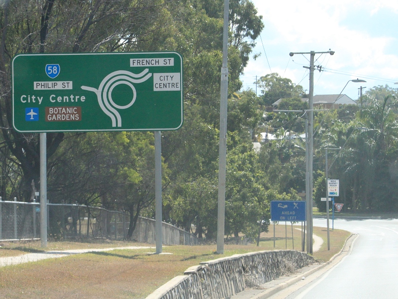
Advance
Directional Sign: AD sign on Glenlyon Rd (SR58) approaching Bramston St and Dawson Hwy (SR60) at Gladstone, June 2010. Image © Rob Tilley |
 |
Advance Directional Sign: AD sign on Port Curtis Way (SR58) approaching Glen Eden Dr at Glen Eden, June 2010. Image © Rob Tilley |
|
 |
Advance
Directional Sign: AD sign using NR shields instead of SR shields on Tank St in Gladstone, approaching Glenlyon Rd (SR58), January 2014. Image © Terry Siva |
|
 |
Advance Directional
Sign: AD sign on Port Curtis Way (SR58) approaching Dalrymple Dr at Toolooa, June 2010. Image © Rob Tilley |
 |
Advance
Directional Sign: AD sign at South Gladstone on French St approaching Philip St (SR58) and Port Curtis Way (SR58), June 2010. Note the missing SR58 shields. Image © Rob Tilley |
 |
Advance Directional Sign: AD sign approaching Philip St (SR58) and French St in South Gladstone, June 2010. Image © Rob Tilley |
|
 |
Intersection
Directional
Sign: ID sign at South Gladstone at the roundabout with French St, Philip St (SR58) and Port Curtis Way (SR58), June 2010. Image © Rob Tilley |
 |
Advance Directional Sign: AD sign approaching Philip St (SR58) and French St in South Gladstone, June 2010. Image © Rob Tilley |
|
 |
Distance
Sign: Reassurance directional sign on Port Curtis Way (SR58) at South Gladstone, June 2010. Image © Rob Tilley |
 |
Intersection
Directional Sign: ID sign at the roundabout with Hanson Rd (SR58), Port Curtis Way (SR58), Alforourke Dr and Blain Dr at Callemondah, June 2010. Image © Rob Tilley |
|
 |
Intersection
Directional
Sign: ID sign at the corner of Port Curtis Way (SR58) and Glen Eden Dr at Glen Eden, June 2010. Image © Rob Tilley |
 |
Advance Directional Sign: AD sign on Port Curtis Way (SR58) approaching Red Rover Rd at Callemondah, June 2010. Image © Rob Tilley |
|
 |
Advance
Directional Sign: AD sign on Port Curtis Way (SR58) approaching Boyne Island Rd at Wurdong Heights, June 2010. Note the incorrect NR58 shield and remnant NH1 shield. Image © Rob Tilley |
 |
Intersection
Directional Sign: ID sign at the roundabout of Port Curtis Way (SR58) and Red River Rd at Callemondah, June 2010. Image © Rob Tilley |
|
 |
Intersection
Directional
Sign: ID sign on Port Curtis Way (SR58) at the roundabout with Boyne Island Rd at Wurdong Heights, June 2010. Image © Rob Tilley |
|||
 |
Distance
Sign: RD sign as Port Curtis Way (SR58) leaves Wurdong Heights, June 2010. Image © Rob Tilley |
|||
 |
Advance
Directional Sign: AD sign approaching Bruce Hwy (A1) at Benaraby, June 2010. Image © Rob Tilley |
|||
 |
Bruce
Highway: Port Curtis Way (SR58) at the junction with Bruce Hwy (A1) at Benaraby, June 2010. Image © Rob Tilley |
|
||
 |
Bruce
Highway: Port Curtis Way (SR58) at the junction with Bruce Hwy (A1) at Benaraby, June 2010. Image © Rob Tilley |
|
||
Last updated: 23:1:32 21/3/2015.
This site © Paul Rands. All rights reserved. Some portions © (copyright) by their respective and credited owners. Permission must be obtained before using any images from this site. For details, please email by clicking here.